https://doi.org/10.36253/bsgi-7613
Digitisation and Geographical Technologies for Sustainability: A Comparative Analysis of “Other Effective Area-Based Conservation Measures” Advancements in Mexico and Italy
Digitalizzazione e tecnologie geografiche per la sostenibilità: un’analisi comparativa dei progressi delle “Other Effective Area-Based Conservation Measures” in Messico e in Italia
Università Niccolò Cusano, Roma, Italy
e-mail: alfonso.giordano@unicusano.it
Abstract. This article analyses the transformative potential of digitalisation and geographic technologies in advancing Other Effective Area-Based Conservation Measures (OECMs) through a comparative analysis between Mexico and Italy. The research addresses the gap identified in the literature regarding the practical application of digital tools for recognising and managing OECMs in various geographical and institutional contexts. Specific objectives include: (1) assessing how geographic technologies support the identification of potential OECMs; (2) analysing differences in national approaches to OECM recognition; (3) identifying opportunities and challenges in integrating digital tools with participatory governance.
Keywords: OECMs, digitisation, geographic technologies, conservation, participatory governance.
Riassunto. Questo articolo analizza il potenziale trasformativo della digitalizzazione e delle tecnologie geografiche nell’avanzamento delle Other Effective Area-Based Conservation Measures (OECM) attraverso un’analisi comparativa tra Messico e Italia. La ricerca affronta la lacuna identificata nella letteratura riguardo l’applicazione pratica di strumenti digitali per il riconoscimento e la gestione delle OECM in contesti geografici e istituzionali diversi. Gli obiettivi specifici includono: (1) valutare come le tecnologie geografiche supportino l’identificazione di potenziali OECM; (2) analizzare le differenze negli approcci nazionali al riconoscimento OECM; (3) identificare opportunità e sfide nell’integrazione di strumenti digitali con governance partecipativa.
Parole chiave: OECM, digitalizzazione, tecnologie geografiche, conservazione, governance partecipativa.
Contents
1. Introduction. Digitisation, Geographical Technologies, and OECMs: A New Frontier in Conservation
2. OECMs: Concept, policy context and distinctions
2.1. Research Advances and Challenges in Latin America and Europe
4. Comparing Conservation Pathways: Mexico and Italy’s Diverse Approaches to OECMs
6. Conclusions: Preparing the Ground for OECMs Through Digital and Geographical Innovation
1. Introduction. Digitisation, Geographical Technologies, and OECMs: A New Frontier in Conservation
The conservation science field is experiencing a digital revolution that is fundamentally transforming environmental stewardship practices (Jouan, Hallot 2020). The emergence of digitisation and geographical technologies has provided unprecedented capabilities in data collection, analysis, and application for conservation efforts (Adams 2020; Casagrande et al. 2018). Within this context, the “Other Effective Area-Based Conservation Measures” (OECMs), distinct yet complementary to traditional Protected Areas (PAs), have gained significant traction as a response to global ecological degradation, offering diverse governance types and management approaches (Negret et al. 2024).
OECMs represent areas where biodiversity conservation results from sustainable management practices rather than being the primary objective, encompassing Indigenous territories, private lands, and restricted zones where ecological preservation is achieved as a secondary outcome. This flexible approach supports biodiversity and socioeconomic values (Rodríguez-Rodríguez, Martínez-Vega 2022). Their growing prominence reflects the need for more inclusive conservation strategies (Alves-Pinto et al. 2021). Following their contribution to the Aichi Biodiversity Targets, OECMs are now aligned with the Kunming-Montreal Global Biodiversity Framework adopted at COP15 in 2022, aiming to conserve thirty percent of global land and marine areas by 2030 (Schröter et al. 2023).
Despite growing global interest in OECMs, a significant gap remains in research on the practical application of digital technologies for their recognition and management, particularly in contexts characterised by different governance models. Recent studies have primarily focused on the theoretical and regulatory frameworks of OECMs (Jonas et al., 2024; Cook 2024), while empirical analysis of the integration between digital tools and participatory governance remains limited. Furthermore, the existing literature has not adequately analysed regional specificities in the implementation of OECMs, tending towards universalistic approaches that give little consideration to differences in institutional systems, conservative traditions and technological capabilities.
The integration of digitisation and geographical technologies marks a significant paradigm shift. Geography’s unique position in bridging natural and social sciences provides essential insights for addressing sustainability challenges, particularly in analysing spatial dynamics and human-environmental interactions underlying sustainable development goals (Fu 2020). GIS (Nowak et al. 2020), remote sensing technologies (Radočaj et al. 2020), and conservation technology are enhancing OECM value through refined spatial planning, real-time monitoring, and adaptive management practices (Fujihira 2023), offering enhanced capabilities to map, measure, and maximize their impact. The digital age presents immense opportunities to align conservation science with technological advancements and sustainable development goals.
This research aims to address three specific objectives: first, to assess how GIS, remote sensing, and citizen science concretely support the identification of areas with OECM potential; second, to comparatively analyse Mexico’s and Italy’s approaches to OECM recognition, highlighting how different institutional contexts influence technological implementation; third, to identify opportunities and limitations in integrating digital tools with participatory governance models characteristic of OECMs. The paper is structured as follows: Section 2 provides the conceptual framework for OECMs; Section 3 examines the role of geographic technologies; Sections 4 and 5 present the comparative analysis between Mexico and Italy; Section 6 discusses implications for research and practice.
2. OECMs: Concept, policy context and distinctions
OECMs are a recent but increasingly significant concept within international conservation policy (Cook 2024). The Convention on Biological Diversity (CBD) defined them in 2018 as “a geographically defined area other than a Protected Area, which is governed and managed in ways that achieve positive and sustained long-term outcomes for the in-situ conservation of biodiversity, with associated ecosystem functions and services and where applicable, cultural, spiritual, socio-economic, and other locally relevant values” (Convention on Biological Diversity 2018). OECMs broaden the scope of conservation beyond traditional protected areas, recognising the contributions of private lands, Indigenous territories, and community-conserved areas (Fitzsimons et al. 2024). Since this definition was adopted recently, many countries have yet to submit data to the World Database on OECMs. However, as stated on the database website, this absence of data does not imply a lack of OECMs within those countries. Often, OECMs are pre-existing areas that have not traditionally been acknowledged for their conservation value, including places like Sacred Natural Sites and certain military zones (UNEP-WCMC 2024).
The policy context for OECMs has evolved through various international agreements and targets. The inclusion of OECMs in Aichi Biodiversity Target 11 was pivotal in galvanising global recognition, calling for conserving at least seventeen per cent of terrestrial and inland water areas and ten per cent of coastal and marine areas through effectively managed systems by 2020 (Donald et al. 2019; MacKinnon et al. 2020a). With the adoption of the Kunming-Montreal Global Biodiversity Framework at COP15 in 2022, OECMs are expected to play an even more significant role in global conservation efforts, targeting thirty per cent of global land and marine areas by 2030 (Schröter et al. 2023; China Council for International Cooperation on Environment and Development Secretariat 2023). Adapting protected area management strategies to address both direct and indirect impacts of climate change is critical to ensuring the long-term conservation of biodiversity and ecosystem services. This necessity underscores the importance of integrating OECMs into conservation frameworks (Ranius et al. 2023). However, for OECMs to be effective, they must be recognised and supported within national and international policy contexts (Dudley et al. 2018).
Understanding the distinctions between PAs and OECMs is crucial in global conservation (Fig. 1). PAs are primarily designed for biodiversity preservation, while OECMs represent areas where sustainable management practices lead to biodiversity conservation as a secondary outcome (Mitchell et al. 2018). Recent findings indicate that OECMs can significantly support biodiversity conservation and recovery across both landscape and marine environments, enhancing habitat connectivity and offering flexible governance models (Beazley et al. 2021; Petza et al. 2024). As IUCN defines, PAs are delineated geographical spaces managed for long-term conservation of nature (Lauche 2011). OECMs are recognised for their effective contributions to biodiversity conservation in areas not designated as protected, including territories governed by Indigenous peoples and local communities. While PAs typically fall under national jurisdiction, OECMs may be governed by more diverse entities, including NGOs and private entities, with more flexible governance integrating customary practices (Lewis et al. 2023).
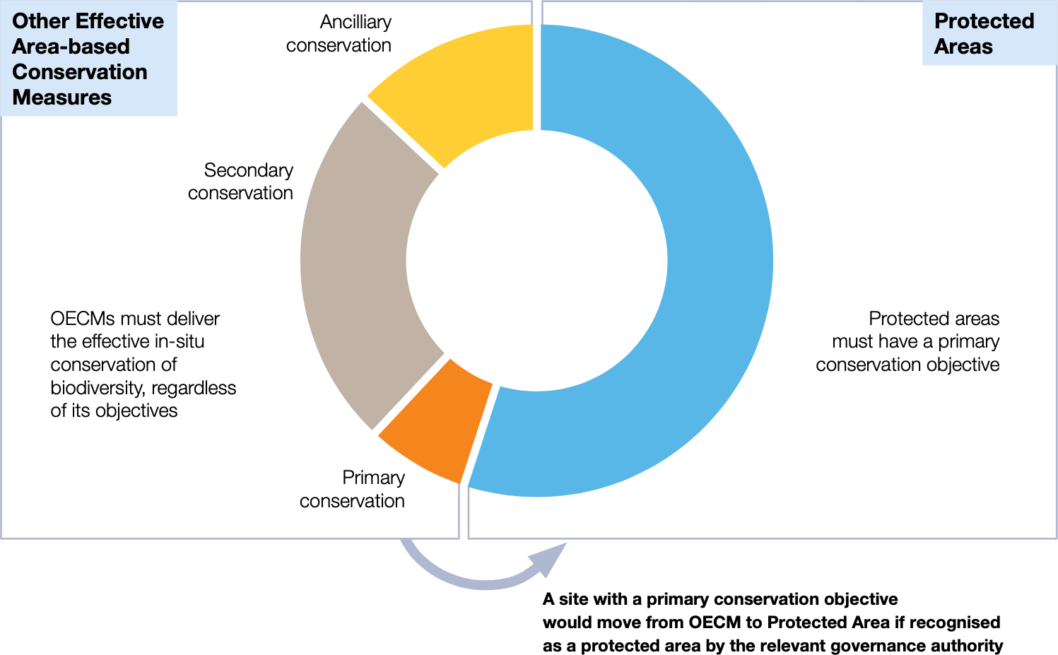
The objectives of PAs focus on biodiversity conservation, while OECMs may have broader primary objectives, including cultural traditions and local economies (Bailey et al. 2022). PAs receive international recognition through the World Database on Protected Areas (WDPA), providing a comprehensive record for conservation reporting and planning. OECMs are identified based on their contribution to effective area-based conservation and reported differently, often through national mechanisms to the CBD (IUCN-WCPA Task Force on OECMs 2019). PAs and OECMs face challenges in governance but enable tailored management strategies and broader stakeholder engagement (MacKinnon et al. 2020b), forming a complementary mosaic of conservation efforts integral to addressing the biodiversity crisis and achieving global sustainability goals.
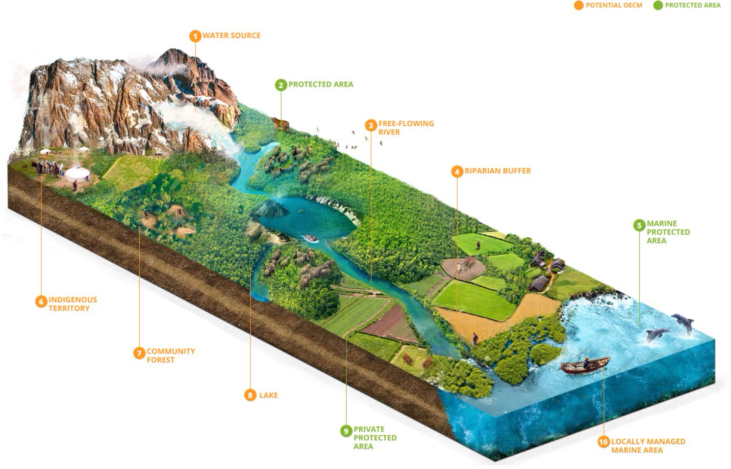
Another essential feature of OECMs is their capacity to enhance ecological connectivity, ensure species movement, and sustain ecosystems. They must address all dimensions of geographical space – length, width, and depth – especially in marine environments, where vertical zoning can undermine conservation. Effective OECMs require clear boundaries that integrate with surrounding areas while anticipating environmental changes. Figure 2 illustrates the multidimensional approach required for effective OECMs, emphasizing the integration of spatial boundaries and ecological connectivity, resulting in networks of protected and conserved areas. Furthermore, they must respect the rights of Indigenous peoples and local communities, ensuring no involuntary displacement and adhering to Free, Prior, and Informed Consent (FPIC), and governance must support in situ conservation, long-term biodiversity protection, and equity (Jonas et al. 2024).
2.1. Research Advances and Challenges in Latin America and Europe
The emerging literature on OECMs in Latin America highlights the importance of Indigenous territories and areas managed by local communities. Recent studies have identified the potential of indigenous reserves in Colombia, which comprise 32 million hectares, including at least 21 million hectares of forests, recognised through “planes de vida” (life plans) that integrate traditional approaches to land management (Jonas et al. 2017). In Brazil, attention has focused on how community-managed protected areas (ICCAs) can qualify as OECMs, with over 499 areas already registered in the global database, representing more than a third of the worldwide total (Jonas et al., 2017). However, significant challenges arise in balancing conservation and land rights, particularly in contexts where extractive pressure and violence against environmental defenders are prevalent.
In Europe, research on OECMs has highlighted significant disparities between Member States in the interpretation and implementation of the concept. The European Environment Agency has commissioned a specific study to assess the potential of OECMs as drivers for landscape-level conservation in the EU, with examples identified in Spain and Finland (European Environment Agency, 2022). OECMs remain relatively unknown in European policy development and implementation, highlighting the urgent need to guide Member States on which measures to prioritise in their National Action Plans. However, challenges remain in standardising assessment criteria and integrating them with existing EU policies.
These regional experiences highlight the need for innovative approaches to support OECM identification and management, particularly through the integration of digital technologies and geographic tools, as explored in the following section.
3. Digital Technologies and Geospatial Innovation: A Framework for Potential OECMs Recognition and Management
The trajectory of ecological research has been profoundly influenced by digital technology (Domínguez et al. 2022). Early conservation efforts relied on manual data collection and analysis, leading to delays and less accurate insights. The digitisation movement began as a quest to enhance data precision and accessibility, evolving into a diverse suite of tools that transform raw data into actionable conservation intelligence (Bakker et al. 2020). Modern conservation uses digital tools to streamline data acquisition, storage, and analysis. Emerging technologies such as biologging and sensor networks enable conservationists to gather comprehensive data with minimal wildlife disturbance (Lahoz-Monfort, Magrath 2021). The application of GIS and remote sensing technologies advances data precision while enabling critical decision-making (De Marchi et al. 2021), laying the foundation for identifying areas suitable for OECMs recognition.
The application of geographical technologies represents a nexus of spatial science and ecological management. GIS, remote sensing, and spatial analysis methods are invaluable for identifying and assessing potential OECMs. These tools offer insights into habitat connectivity and biodiversity representation within protected area networks (Agnesi et al. 2020). GIS excels in organising, analysing, and visualising spatial data, incorporating remote sensing and satellite technologies critical for monitoring potential OECMs (Shabtay et al. 2019). Once exclusive to military and research institutions, high-resolution satellite imagery and aerial photography are now widely accessible, enabling cost-effective monitoring of habitat fragmentation, climate-related changes, and unauthorised activities (Dalton et al. 2022). Spatial analysis facilitates multiple tasks in OECM identification and assessment. This is crucial for several conservation-related tasks (Magdalena, Amorim 2022) and evaluating ecosystem services and development project impacts (Di Minin et al. 2022). These technologies empower stakeholders with data-driven decision-making capabilities while incorporating Indigenous and local knowledge systems into the assessment process (Garnett et al. 2018).
Recent discussions emphasise the need to align technological advancements with societal needs, reflecting how tools like GIS not only advance science but also promote community engagement in conservation efforts (Capineri 2023). Mobile technology and citizen science platforms ensure broad coverage and community participation in OECM identification (Fraisl et al. 2022). Community-based monitoring enhances conservation through inclusive governance and localised management (Danielsen et al. 2022), aligning with the OECM concept by promoting biodiversity conservation outside formal PAs. Digital platforms designed for citizen science demonstrate technology’s impact on OECM identification. Platforms like eBird allow bird enthusiasts to record observations contributing to global species distribution models, iNaturalist enables community-driven species documentation, and the Global Biodiversity Information Facility is an open-data infrastructure fostering collaborative research across borders. Mobile applications enable the rapid collection and upload of field data, while cloud-based platforms aggregate and examine datasets from various sources. Digital mapping tools refine spatial analysis and habitat modelling, enabling conservationists to visualise environmental data more precisely (Jackson et al. 2020).
Real-world applications demonstrate these technologies’ transformative potential. In the Brazilian Amazon, indigenous groups use drones to capture real-time, high-resolution images, providing evidence of unauthorised deforestation, improving enforcement, and reducing illegal incursions in areas that could qualify as OECMs (Custodio, Abeledo 2023; González, Kröger 2022; Perazzoni, Painho 2020). Drones and geographical technologies have been recognised as key drivers for agroecological transitions and conservation efforts, empowering local communities through participatory mapping, precise monitoring, and data sovereignty initiatives (De Marchi et al. 2022). Recent studies highlight the transformative role of drones in participatory processes and environmental justice (De Marchi, Pappalardo 2023). Additionally, machine learning algorithms applied to acoustic data enable continuous wildlife observation without physical presence, providing new possibilities for identifying areas with high conservation value. These cases illustrate how digitisation bolsters conservation while empowering communities and enhancing OECM initiatives’ scalability (Nieto-Mora et al. 2023).
However, digital technologies present significant limitations in OECM implementation, including digital divides that exclude rural and indigenous communities, standardization requirements that conflict with flexible governance models, data sovereignty concerns when communities share sensitive territorial information, and technological dependencies that may weaken traditional knowledge systems and create unsustainable financial burdens for resource-limited communities.
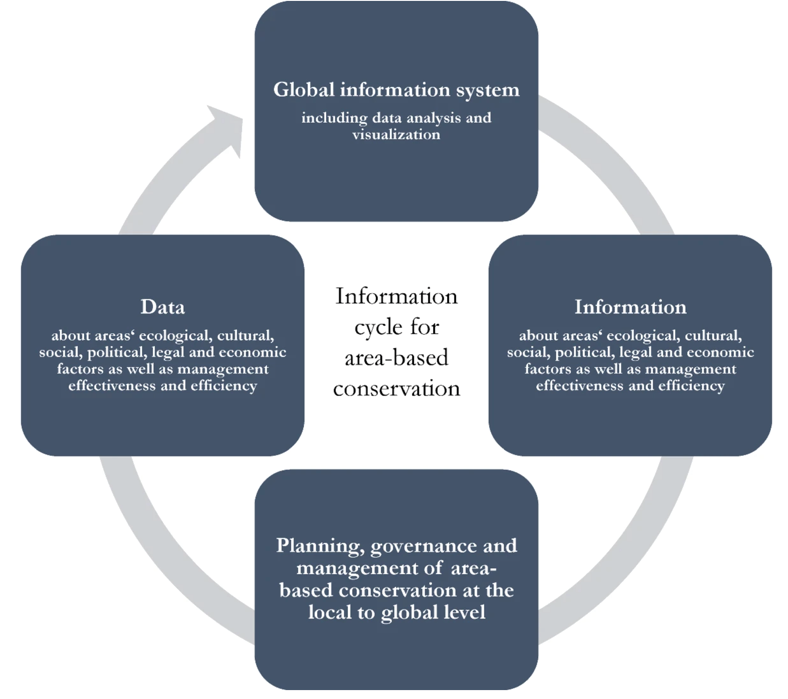
In other words, geographical technologies address two key challenges in potential OECM recognition: ecological connectivity and representativeness. GIS and connectivity modelling identify wildlife corridors and landscape transformations in space and time (Azzari et al. 2021; Kondratenko et al. 2023), while remote sensing ensures diverse ecosystem representation within global conservation portfolios (Wang et al. 2023). Adaptive management, supported by real-time monitoring and scenario analysis, allows potential OECM conservation strategies to evolve with shifting ecological, social, and economic conditions (Dalton et al. 2021). These technologies enable comprehensive data collection by converging digital tools and participatory approaches, fostering collaboration between technical expertise and local knowledge systems. This integration (Fig. 3) exemplifies how modern technology enhances OECM identification and management, supporting scientific rigour and inclusive community participation (Hoffmann 2022).
4. Comparing Conservation Pathways: Mexico and Italy’s Diverse Approaches to OECMs
The decision to compare Italy and Mexico, despite their noticeable geographical and institutional differences, is justified by significant similarities that make them paradigmatic cases for analysing OECMs. Both countries are characterised by: (1) high biodiversity and the presence of global hotspots; (2) the coexistence of formal protected areas with territories managed by local communities according to traditional practices; (3) formal commitments to the 30x30 targets of the Kunming-Montreal Global Framework; (4) challenges in integrating multi-level governance for conservation. The comparison is based on four theoretically grounded analytical variables: (a) degree of progress in the formal recognition of OECMs; (b) types of governance prevalent in potential OECMs; (c) integration of digital technologies in identification and monitoring processes; (d) models of community involvement in conservation management. This comparative analysis allows us to identify cross-cutting patterns in the implementation of OECMs, overcoming geographical specificities to highlight universal principles and challenges in the application of digital technologies to participatory conservation.
Comparative case studies provide essential insights into implementing conservation strategies. Despite distinct geographical and sociopolitical contexts, Mexico’s and Italy’s differing approaches offer a distinct view of OECMs’ recognition steps and implementation challenges. Data from the World Database on Protected Areas (UNEP-WCMC 2024) shows differences between Mexico and Italy’s protected area networks regarding size, management structures, and conservation approaches (Fig. 4 and Fig. 5). Mexico has 1,425 PAs, of which 1,234 are designated at the national level, covering significant ecological zones with a focus on federally managed reserves and community-led conservation initiatives. In contrast, Italy has a much larger number of PAs, totalling 3,955. However, only 875 of these are nationally designated, with the majority being Natura 2000 sites that align with European Union conservation frameworks. Despite Italy’s larger count of PAs, Mexico has conducted a higher number of Management Effectiveness Evaluations (133 assessments compared to Italy’s 26), indicating a more systematic approach to evaluating conservation outcomes. This comparison highlights that while Italy’s protected area network is extensive, Mexico places a stronger emphasis on national-level designations and effectiveness assessments, each country reflecting its unique governance and conservation priorities within global biodiversity targets.
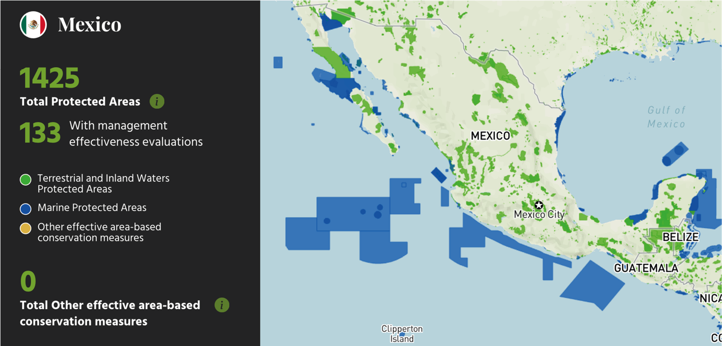
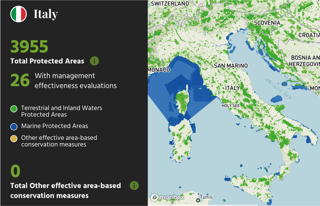
Notably, although both countries have submitted comprehensive geographical representations for their PAs to support spatial analysis and planning, neither Mexico nor Italy have reported OECMs to WDPA, suggesting an opportunity for both countries to recognise additional areas that achieve conservation outcomes outside of traditional protected sites. Indeed, assessments by relevant international bodies highlight the need for more precise criteria and methodologies for identifying and governing OECMs in different contexts (ICES 2021).
Another key distinction lies in the types of ecosystems prioritised, and the governance models used. Mexico’s PAs reflect a variety of ecosystems, including desert regions, tropical forests, and extensive marine environments, with management practices often involving local communities and Indigenous groups. Italy’s PAs focus on Mediterranean ecosystems, alpine regions, and significant marine sites in the Mediterranean Sea, where conservation initiatives are often aligned with broader EU policy objectives rather than locally driven mandates. This focus on traditional, state-recognised PAs may limit Italy’s ability to diversify conservation management. At the same time, Mexico’s approach highlights the integration of community and local governance structures, though with challenges in formal OECM documentation. Both countries thus face unique hurdles: Mexico must improve OECM reporting and data transparency, while Italy may need to expand protected area coverage and explore new governance models to achieve its 30x30 conservation targets.
The progress of both countries toward OECM recognition reflects their geographical characteristics, conservation traditions, goals, organisational structures, and governance actors. Italy must incorporate OECMs into its conservation framework to meet the EU’s target of protecting thirty per cent of land and marine areas by 2030, as outlined in the EU Biodiversity Strategy (European Commission 2020). This strategy emphasises the inclusion of OECMs alongside traditional PAs, broadening landscapes for biodiversity conservation. With accelerating biodiversity loss and protected area targets proving insufficient, OECMs offer an innovative solution for conserving human-dominated and natural ecosystems (Hermoso et al. 2021). Nevertheless, significant disparities remain in OECM adoption across EU member states, with some advancing recognition and governance faster than others (Naumann et al. 2021).
The national coverage of protected areas, net of the overlaps between protected areas and Natura 2000 sites, to date is about 4,068,476 hectares at sea, equal to 11.62% of Italy’s territorial waters and Ecological Protection Areas, and about 6,532,341 on land, equal to 21.68% of Italy’s territory. OECMs could also be considered in the calculation of national areas, but the examination of the types of areas that could appropriately fall into this category is still in progress, so it was not possible to include them in the analysis (Agnesi et al. 2024). Italy’s conservation strategy traditionally focused on PAs like national parks, nature reserves, and Natura 2000 sites (Cazzolla Gatti et al. 2024). For instance, Sacred Natural Sites in Italy protect cultural landscapes at lower elevations that complement the higher-altitude areas covered by traditional PAs, suggesting that rather than being incorporated into existing protection frameworks, these sites could obtain legal status through emerging policy approaches like OECMs (Frascaroli et al. 2019).
However, transitioning to OECM recognition requires redefining criteria to include non-traditional PAs contributing to biodiversity goals (D’Antoni 2022) and addressing institutional fragmentation while improving coordination across governance levels (D’Antoni et al. 2023; Shirvani Dastgerdi et al. 2020). Another challenge is updating Italy’s outdated conservation cartography, much of which is over twenty years old (Comitato per il Capitale Naturale 2022). Rural commons, or “territories of life,” conserved by local communities, align with Indigenous and Community Conservation Areas and OECM frameworks (Ramos, Tugendhat 2021) but remain under-recognised. Formal recognition of these areas could build on Italy’s community-based conservation heritage (Bassi 2022). Italy’s struggle to integrate diverse governance structures reflects broader EU challenges in aligning central biodiversity targets with local governance models (Moreira et al. 2024).
Mexico has made more significant strides along the way in OECM recognition. In a preliminary assessment, 1,029 terrestrial areas have been identified as potential OECMs, of over 54 possible OECM modalities, covering 8.5 million hectares (equivalent to 4.3% of the terrestrial territory). The potential of Indigenous territories to establish OECMs is of utmost relevance: 2,484 plots owned by 39 Indigenous peoples outside PAs cover 1.9 million hectares of conserved ecosystems. 1,320 marine areas have been preliminarily identified as potential OECMs in 15 different modalities, covering 15.13 million hectares, equivalent to 4% of the territorial sea (Fig. 6).
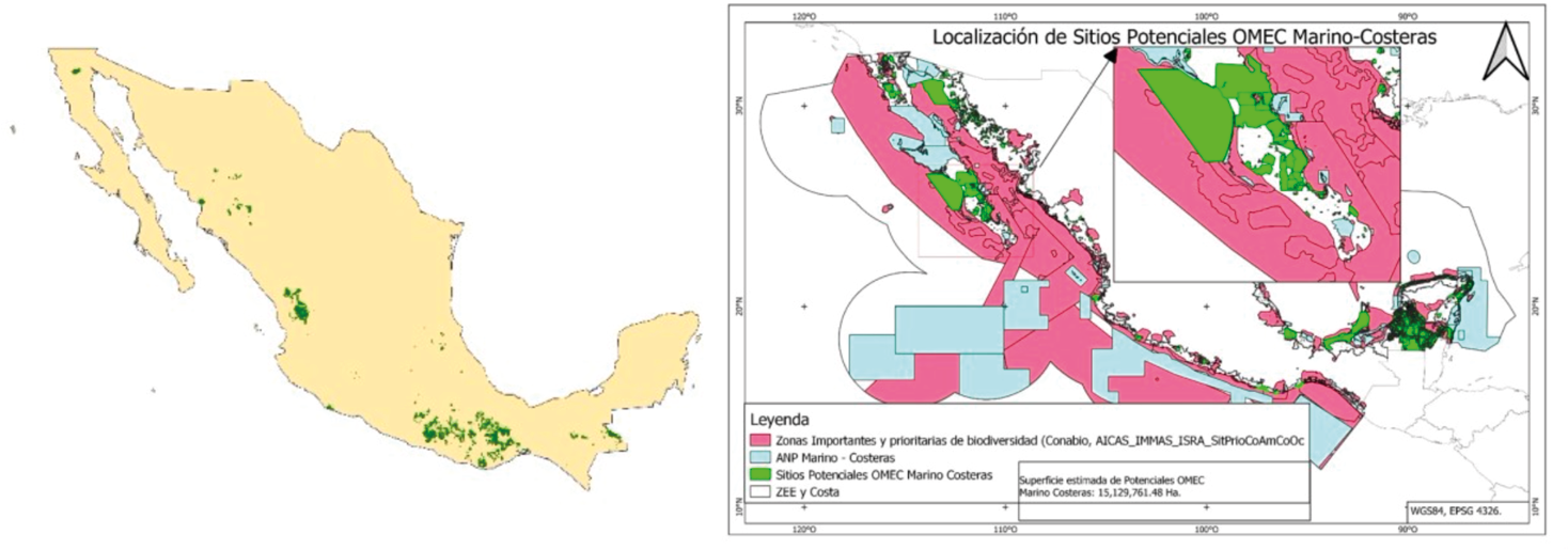
Spatial analysis has shown that over twenty-five per cent of Mexico’s Exclusive Economic Zone (EEZ) is protected through Marine Protected Areas (MPAs) and OECM-eligible sites, placing Mexico on track to meet the 30x30 conservation target. Additional priority regions identified for MPA or OECM designation could further enhance marine biodiversity and resource management (Perera-Valderrama et al. 2023). A review of Mexico’s PPAs from 2012 to 2023 highlights conservation growth through voluntary certification and innovative legal tools, aligning with the Kunming-Montreal Global Biodiversity Framework’s 30x30 target (Bezaury-Creel, 2024). In addition to state-managed PAs, Areas Voluntarily Destined for Conservation (ADVCs) cover over 600,000 hectares across 374 sites, emphasising community-led conservation and collaborative management (Peña-Azcona et al. 2022). Wildlife Management Units (UMAs) on private and communal lands reinforce Mexico’s commitment to conservation beyond traditional PAs. UMAs effectively conserve species while aligning conservation with sustainable development goals by providing connectivity across tropical and montane ecosystems (Gallina et al. 2022). This model offers insights into Italy’s OECM efforts, particularly in engaging landowners and local communities.
A roadmap introduced by Chile and Mexico under the Kunming-Montreal Global Biodiversity Framework outlines plans to protect thirty per cent of terrestrial, freshwater, coastal, and marine areas by 2030, integrating OECMs alongside traditional PAs to achieve ecological, social, and economic goals. Incorporating OECMs supports biodiversity protection through sustainable management and community involvement, fostering resilience and climate adaptation (World Wildlife Fund 2024). Despite progress, challenges persist, including limited stakeholder engagement and underutilisation of local knowledge in UNESCO Biosphere Reserves (Brenner, Job 2022).
The differences between Mexico and Italy in OECM recognition highlight the importance of governance and community engagement in conservation. Italy’s centralised approach to conservation, while robust in traditional PAs, has delayed its transition to more flexible OECM frameworks. Mexico’s progress, facilitated by community involvement, illustrates the potential of decentralised conservation models. Both countries face unique challenges under the EU Biodiversity Strategy 2030’s framework and the global 30x30 targets.
5. Digital Technologies and Geographical Tools in Environmental Sustainability: Initiatives in Mexico and Italy and their Potential Application for Future OECMs Recognition
Integrating digitisation, geographical tools, and the OECM concept creates a dynamic framework for conservation. Data-driven and participatory approaches, such as citizen science, enhance resilience and sustainability, potentially revolutionising OECM governance and global biodiversity conservation (Gurney et al. 2021). This synergy is evident in various conservation successes in Mexico.
A study on forest degradation in Mexico analysed trends in Moderate Resolution Imaging Spectroradiometer (MODIS) Leaf Area Index (LAI) data, a key vegetation health indicator. Using time-series analysis, the authors (Reygadas et al. 2018) assessed forest cover changes and degradation from 2001 to 2017. The findings identified degradation hotspots in areas of high anthropogenic pressure, providing valuable insights for conservation planning and environmental monitoring in Mexico. Alterations in land use affecting streamflow dynamics in the Pixquiac River catchment, a crucial water source for Xalapa (capital of Veracruz, southern Mexico), have been analysed using the Soil and Water Assessment Tool (SWAT). The research (López-Ramírez et al. 2020) simulated streamflow under different land use scenarios, including current conditions, historical land cover, and potential future changes. The findings reveal that deforestation and urbanisation increase runoff and flood risks while reducing water availability during dry periods. Reforestation, however, enhances water stability by increasing baseflows and reducing peak flows. This study underscores the importance of sustainable land management in maintaining water resources in tropical montane regions.
A study (David et al. 2021) in Coatzacoalcos, Veracruz, used remote sensing and GIS tools to monitor land use and land cover changes, analysing environmental impacts and urbanisation effects over time. Satellite image analysis revealed significant shifts, such as forest reduction and urban expansion, offering critical insights for sustainable land management and planning. The study highlights the importance of remote sensing in environmental monitoring and policymaking for developing regions. Another example is the creation of “Quiahua”, Mexico’s first citizen science rainfall monitoring network, established to address gaps in rainfall data crucial for evaluating a Payment for Hydrologic Services (PHS) program. Between June 2017 and February 2019, volunteers collected rainfall data in two watersheds in Veracruz, integrating findings into hydrological models to improve conservation policy (Shinbrot et al. 2020). This initiative demonstrates the role of citizen science in bridging data gaps, enhancing environmental monitoring, and informing policy mechanisms like PHS programs. The Quiahua case shows how community-driven initiatives, aligned with the OECM model, can contribute to hydrological and conservation goals in a participatory and scientifically robust manner. These efforts align with broader regional experiences that leverage nature-based solutions to simultaneously reduce disaster risks and enhance ecological and social resilience (Lucatello, Alcántara-Ayala 2024).
Mexico’s progress in biodiversity conservation is bolstered by digital platforms and government resources that promote citizen science and public engagement (Monzón Alvarado et al. 2020). Citizen science tools include CONANP’s1 Visor for protected area data, Xeno-canto for bird recordings, iNaturalist for biodiversity observations, Enciclovida for species information, and eBird Mexico for avian sightings. Government resources such as SEMARNAT’s2 Environmental Indicators Portal, CONAGUA’s3 Water Systems, CONABIO’s4 GIS information, INECC’s5 Vulnerability Atlas, and the National Ethnic Groups Database further support conservation and monitoring. These technologies enable real-time data collection and adaptive management strategies, improving conservation outcomes while enhancing transparency and accountability in upcoming OECM governance.
In Italy, remote sensing and GIS technologies are critical in environmental monitoring and land-use planning, particularly in addressing climate change and land degradation. In Basilicata, a region impacted by intensive land transformations, high-resolution satellite data and machine learning algorithms, such as Support Vector Machine (SVM), have been used to classify land cover changes and identify areas at risk of soil degradation (Santarsiero et al. 2022). This application supports sustainable land-use policies by providing accurate data on urban expansion’s effects on natural and agricultural landscapes. Additionally, the MEDALUS6 framework, adapted for Italy, evaluates desertification vulnerability using indicators like soil quality, vegetation cover, and climate, offering a systematic approach to landscape management and climate adaptation (Gabriele et al. 2023). These tools are essential for promoting climate resilience and mitigating land degradation in sensitive areas.
A compelling case study on the Sorrentina Peninsula highlights the application of GIS and remote sensing to map landslide susceptibility, reflecting a proactive approach to disaster risk reduction. Researchers combined InSAR (Interferometric Synthetic Aperture Radar) data with GIS analyses to detect ground deformations and identify high-risk zones, enabling effective resource allocation and sustainable land management (Spinetti et al. 2019). Similarly, in the Valle Savio region, part of the Adriadapt Interreg project, remote sensing and spatial modelling were used to assess climate threats such as drought, urban flooding, and landslides. By integrating vegetation health indicators and hydrological modelling, GIS analyses mapped land vulnerability, offering a basis for climate-resilient planning. The findings advocate for climate-sensitive regional practices to mitigate risk and promote sustainability (Pozzer et al. 2021).
Italy’s biodiversity conservation efforts are also strengthened by digital platforms and government resources promoting citizen science. The Italian Citizen Science Observatory coordinates initiatives nationwide, promoting best practices in participatory research. OpenScience.it fosters collaboration between scientists and citizens, supporting projects like CSMON-LIFE for biodiversity monitoring and BioBlitz activities organised by the National Museum of Natural Sciences. Platforms such as Naturaitalia provide PA data, while the Marine Invasive Database enables marine biodiversity monitoring. Government resources include ISPRA’s7 Environmental Data Bank, the National Geoportal, and the National Agricultural Information System for land use monitoring. Regional tools like Tuscany’s GEOscopio and Lombardy’s Geoportal engage citizens in environmental monitoring. These resources, along with European platforms like EU-BON and the Global Biodiversity Information Facility, enhance Italy’s environmental management and support the implementation of OECM governance principles.
In both countries, digital technologies enhance conservation efforts and promote participatory environmental governance. Citizen science platforms engage inhabitants in data collection, fostering shared responsibility. Integrating advanced technologies with community involvement in Italy and Mexico demonstrates how digital tools improve conservation governance and sustainability outcomes. These initiatives advance biodiversity protection and support sustainable development goals, which are central to the conceptualisation and implementation of OECMs.
6. Conclusions: Preparing the Ground for OECMs Through Digital and Geographical Innovation
The integration of digitisation and geographical technologies represents a significant advancement for potential OECMs recognition and management, offering innovative tools for biodiversity conservation (Maxwell et al. 2020). This contribution has explored how tools such as GIS, remote sensing, digital data collection, and spatial analysis enhance planning and monitoring capabilities, particularly in contexts where formal OECM recognition is still pending, as in Mexico and Italy. The cases of Mexico and Italy illustrate different pathways toward potential OECM recognition. In Mexico, the experience with Areas Voluntarily Destined for Conservation and Wildlife Management Units demonstrates how digital tools can support community-based conservation initiatives. Similarly, Italy’s evolving approach to conservation, mainly through its engagement with EU biodiversity targets and the application of geographical technologies in areas like the Basilicata region, shows how digital innovation can prepare the ground for future OECM recognition.
The intersection between geographic tools and community involvement represents a particularly promising area of research. In Mexico, the integration of digital technologies with traditional Indigenous governance has demonstrated how citizen science platforms can reinforce local knowledge systems. The case of the Quiahua monitoring network illustrates how technologies can bridge traditional knowledge and scientific requirements. In Italy, the application of GIS and remote sensing in Basilicata and the Sorrentine Peninsula shows that the effectiveness of such tools depends significantly on community involvement. This is particularly relevant for Italian contexts like Sacred Natural Sites and rural commons, often managed by communities with traditional ecological knowledge.
As biodiversity loss accelerates globally, these technological advances offer promising pathways for enhancing conservation effectiveness. However, realising this potential requires addressing key challenges: institutional capacity building, data standardisation, technological accessibility and governance innovation (Rabitz et al. 2022). These challenges are compounded by broader geopolitical and geoeconomic dynamics shaping national strategies in technological competition, which in the Italian case have been analysed in relation to global innovation trajectories (Giordano 2026). The experiences of both countries suggest that successful implementation depends on developing robust policy frameworks that can accommodate OECMs once formally recognised, strengthening international collaboration while respecting local contexts, ensuring equitable access to technology and data-sharing protocols, and building capacity for community-based monitoring and management. Future research should focus on developing participatory methodologies that integrate advanced geographic technologies with Free, Prior, and Informed Consent (FPIC) protocols, ensuring that technological implementation does not compromise the rights of local and indigenous communities. This includes developing cost-effective technologies for widespread adoption, examining how digital innovations can support climate change adaptation, and exploring how digital platforms can be designed to support polycentric governance models characteristic of OECMs rather than perpetuating centralised approaches typical of traditional protected areas. The path forward requires collaboration among geographers, conservationists, technologists, social scientists, policymakers, and communities to create systems that respect both natural ecosystems and technological advancement.
This study presents some methodological considerations that suggest directions for future research. The analysis relies primarily on secondary sources and official documents, suggesting that direct stakeholder engagement could complement these findings. The focus on two case studies, while theoretically justified, suggests that expanded comparative analysis could enhance generalizability. A broader analysis of socio-economic dynamics, land-use conflicts, and climate adaptation strategies could complement the emphasis on digital technologies. The temporal scope, primarily covering recent developments, indicates a potential for longitudinal studies to assess the long-term evolution of conservation initiatives.
Both countries’ experiences suggest that while formal OECM recognition may be pending, the groundwork laid through technological innovation and community engagement provides a strong foundation for future conservation success. This understanding will be crucial as countries work toward meeting global biodiversity targets while ensuring effective, equitable, and sustainable conservation outcomes, contributing meaningfully to the global effort to live harmoniously with nature, and adapting and harnessing the power of technology for future generations.
Acknowledgments
This contribution has been developed in the framework of the programme “PRODIGEES – Promoting Research on Digitalisation in Emerging Powers and Europe Towards Sustainable Development”, supported by the European Union’s Horizon 2020 research and innovation programme under the Marie Skłodowska-Curie grant agreement No 873119. The author has been seconded by LUISS University of Rome at the Research Institute Dr. José María Luis Mora, Mexico City.
References
Adams, W. M. (2020). Geographies of Conservation III: Nature’s Spaces. Progress in Human Geography, 44(4), 789-801. DOI: https://doi.org/10.1177/0309132519837779
Agnesi et al. (2024). Superfice nazionale protetta terrestre e marina. Roma, Istituto Superiore per la Protezione e la Ricerca Ambientale. https://indicatoriambientali.isprambiente.it/it/aree-tutelate/superficie-nazionale-protetta-terrestre-e-marina
Agnesi, S. et al. (2020). Spatial Analysis of Marine Protected Area Networks in Europe’s Seas III. ETC/ ICM Technical Report 3/2020: European Topic Centre on Inland, Coastal and Marine waters. https://www.eionet.europa.eu/etcs/etc-icm/products/etc-icm-reports/etc-icm-report-3-2020-spatial-analysis-of-marine-protected-area-networks-in-europe2019s-seas-iii
Alves-Pinto et al. (2021). Opportunities and Challenges of Other Effective Area-based Conservation Measures (OECMs) for Biodiversity Conservation. Perspectives in Ecology and Conservation, 19(2), 115-120. DOI: https://doi.org/10.1016/j.pecon.2021.01.004
Azzari, M. et al. (2021). Virtual Reconstruction of Historical Landscapes: A 3D Environment to Contextualise Data in Space and Time. Abstracts of the International Cartographic Association, 3, 17. DOI: https://doi.org/10.5194/ica-abs-3-17-2021
Bailey J. J. Cunningham, C. A., Griffin, D. C., Hoppit, G., et al. (2022). Protected Areas and Nature Recovery. Achieving the goal to protect 30% of UK land and seas for nature by 2030. London, British Ecological Society. www.britishecologicalsociety.org/protectedareas
Bakker, K. et al. (2020). Digital Technologies and Dynamic Resource Management, 2020 IEEE International Conference on Smart Computing, Piscataway, IEE Computer Society, 368–373. DOI: https://doi.org/10.1109/SMARTCOMP50058.2020.00079
Bassi, M. (2022). Territories of Life in Europe: Towards a Classification of the Rural Commons for Biodiversity Conservation. Antropologia Pubblica, 8(2), 102-121. DOI: https://doi.org/10.1473/anpub.v8i2.279
Beazley, L. et al. (2021). Other Effective Area-based Conservation Measure Promotes Recovery in a Cold-water Coral Reef. Global Ecology and Conservation, 26, e01485. DOI: https://doi.org/10.1016/j.gecco.2021.e01485
Bezaury-Creel, J. E. (2024). Privately Protected Areas in Mexico, a 2012–2023 Update. Frontiers in Conservation Science, 4, Article 1304771. DOI: https://doi.org/10.3389/fcosc.2023.1304771
Brenner, L., Job, H. (2022). Reviewing the Participatory Management of UNESCO Biosphere Reserves: What do We Miss by Ignoring Local Academic Knowledge in Mexico? Ambio, 51(8), 1726-1738. DOI: https://doi.org/10.1007/s13280-021-01672-1
Capineri, C. (2023). Quale tecnologia per quale geografia, quale geografia con quale tecnologia. In Lazzeroni, M. et al. (Eds.), Geografia e tecnologia: Transizioni, trasformazioni, rappresentazioni. Memorie geografiche, 22, Firenze, Società di Studi Geografici, 17-22.
Casagrande, G., Sik, A., Gergely, S. (Eds., 2018). Small Flying Drones: Applications for Geographic Observation. Berlin, Springer. DOI: https://doi.org/10.1007/978-3-319-66577-1
Cazzolla Gatti, R. et al. (2024). EU2030 Biodiversity Strategy: Unveiling Gaps in the Coverage of Ecoregions and Threatened Species Within the Strictly Protected Areas of Italy. Journal for Nature Conservation, 79, 126621. DOI: https://doi.org/10.1016/j.jnc.2024.126621
China Council for International Cooperation on Environment and Development Secretariat (2023). Post-2020 Global Biodiversity Conservation. In: Green Recovery with Resilience and High-Quality Development. In China Council for International Cooperation on Environment and Development Secretariat. Green Recovery with Resilience and High- Quality Development. CCICED Annual Policy Report 2021. Singapore, Berlin, Springer, 59-124. DOI: https://doi.org/10.1007/978-981-19-9470-8_2
Comitato per il Capitale Naturale. (2022). Quinto rapporto sullo stato del capitale naturale in Italia. Roma, Ministero dell’Ambiente e della Sicurezza Energetica. Retrieved from: https://www.mase.gov.it/sites/default/files/archivio/allegati/CapitaleNaturale/V_Rapporto_CN.pdf
Convention on Biological Diversity (2018). Decision adopted by the Conference of the Parties to the CBD 14/8. Protected Areas and Other Effective Area-based Conservation Measures. Conference of the Parties to the Convention on Biological Diversity Fourteenth meeting, Sharm El-Sheikh, Egypt, 17-29 November.
Cook, C. N. (2024). Progress Developing the Concept of Other Effective Area-based Conservation Measures. Conservation Biology, 38(1), e14106. DOI: https://doi.org/10.1111/cobi.14106
Custodio, J., Abeledo, H. (2023). Drone-Based Environmental Emergency Response in the Brazilian Amazon. Drones, 7(9), 554. DOI: https://doi.org/10.3390/drones7090554
D’Antoni, S. (2022). Aree protette, un pilastro della conservazione. Ecoscienza, Rivista dell’Agenzia regionale prevenzione, ambiente ed energia dell’Emilia-Romagna, 13(2), 2022. https://www.arpae.it/it/ecoscienza/numeri-ecoscienza/anno-2022/numero-2-anno-2022/biodiversita/dantoni_es2022_2-1.pdf
D’Antoni, S. et al. (2023). Criteri per l’individuazione di aree da sottoporre a tutela per il raggiungimento degli obiettivi della Strategia Europea per la Biodiversità al 2030. Reticula, 32, 5-23. https://www.isprambiente.gov.it/files2023/pubblicazioni/periodici-tecnici/reticula/reticula_32.pdf
Dalton, D. T., Pascher, K., Berger, V., Steinbauer, K., Jungmeier, M. (2021). Novel Technologies and Their application for Protected Area Management: A Supporting Approach in Biodiversity Monitoring. In Suratman, M. N. (Ed.), Protected Area Management - Recent Advances. London, IntechOpen, 571-483. DOI: https://doi.org/10.5772/intechopen.99889
Dalton, D. T., Berger, V., Adams, V. et al (2022). A Conceptual Framework for Biodiversity Monitoring Programs in Conservation Areas. Sustainability, 15(8), 6779. DOI: https://doi.org/10.3390/su15086779
Danielsen, F., Eicken, H., Funder, M. et al. (2022). Community Monitoring of Natural Resource Systems and the Environment. Annual Review of Environment and Resources, 47, 637-670. DOI: https://doi.org/10.1146/annurev-environ-012220-022325
David, J. et al. (2021). Application of Remote Sensing Tools to Assess the Land Use and Land Cover Change in Coatzacoalcos, Veracruz, Mexico. Applied Sciences, 12 (4), 1882. DOI: https://doi.org/10.3390/app12041882
De Marchi et al. (2022). Drones and Geographical Information Technologies in Agroecology and Organic Farming: Contributions to Technological Sovereignty. Boca Raton, CRC Press. DOI: https://doi.org/10.1201/9780429052842
De Marchi, M. et al. (Eds., 2021). Geografie in movimento: Strumenti, tecnologie, dati GIS, luoghi, sensori, attori (Vol. 5). XXXIII Congresso Geografico Italiano, Padova, 8-13 settembre 2021.
De Marchi, M., Pappalardo, S. E. (2023). Drones for Good, tecnologie dell’informazione geografica e processi di empowerment. In Lazzeroni, M. et al. (Eds.). Geografia e tecnologia: Transizioni, trasformazioni, rappresentazioni. Firenze, Società di Studi Geografici, 769-774.
Di Minin, E. et al. (2022). Quantitative Conservation Geography. Trends in Ecology & Evolution, 37(1), 42-52. DOI: https://doi.org/10.1016/j.tree.2021.09.005
Domínguez, J. C. et al. (2022). Back to the Future. Smart Technologies and the Sustainable Development Goals. In Kurz, H. D. et al. The Routledge Handbook of Smart Technologies. London, Routledge, 537-554.
Donald, P. F. et al. (2019). The Prevalence, Characteristics and Effectiveness of Aichi Target 11’s “Other Effective Area-based Conservation Measures” (OECMs) in Key Biodiversity Areas. Conservation Letters, 12 (5), e12659. DOI: https://doi.org/10.1111/conl.12659
Dudley, N. et al. (2018). The Essential Role of Other Effective Area-based Conservation Measures in Achieving Big Bold Conservation Targets. Global Ecology and Conservation, 15, e00424. DOI: https://doi.org/10.1016/j.gecco.2018.e00424
European Commission. (2020). EU Biodiversity Strategy for 2030: Bringing nature back into our lives (COM(2020) 380 final). Communication from the Commission to the European Parliament, the Council, the European Economic and Social Committee, and the Committee of the Regions. Publications Office of the European Union. Retrieved from: https://eur-lex.europa.eu/legal-content/EN/TXT/HTML/?uri=CELEX:52020DC0380
European Environment Agency. (2021). Assess the Potential of Other Effective Area-based Conservation Measures as a Driver for Landscape-level Conservation and Connectivity in the EU. UNEP-WCMC, IEEP, and Trinomics report. Retrieved from: https://biodiversity.europa.eu/europes-biodiversity/protected-areas-archived/other-effective-area-based-conservation-measures/final_report_oecms_in_eu_submitted_2021031.pdf/@@download/file
Fitzsimons, J. A. et al. (2024). Editorial: Advances in Privately Protected Areas. Frontiers in Conservation Science, 5, 1441046 https://doi.org/10.3389/fcosc.2024.1441046
Fraisl, D. et al. (2022). Citizen Science in Environmental and Ecological Sciences. Nature Reviews Methods Primers 2(1), 1-20. DOI: https://doi.org/10.1038/s43586-022-00144-4
Frascaroli, F. et al. (2019). Sacred Natural Sites in Italy Have Landscape Characteristics Complementary to Protected Areas: Implications for Policy and Planning. Applied Geography, 113, 102100. DOI: https://doi.org/10.1016/j.apgeog.2019.102100
Fu, B. (2020). Promoting Geography for Sustainability. Geography and Sustainability, 1(1), 1-7. DOI: https://doi.org/10.1016/j.geosus.2020.02.003
Fujihira, K. (2023). Sustainable Land Development: Biodiversity, Natural Disasters, and Topographic Gradient. In Almusaed, A., Almssad, A. Sustainable Regional Planning. London, IntechOpen DOI: https://doi.org/10.5772/intechopen.110235
Gabriele, M. et al. (2023). A Combined GIS and Remote Sensing Approach for Monitoring Climate Change-related Land Degradation to Support Landscape Preservation and Planning Tools: The Basilicata Case Study. Applied Geomatics, 15, 497-532. DOI: https://doi.org/10.1007/s12518-022-00437-z
Gallina, S. et al. (2022). Contribution of Wildlife Management Units to the Conservation of Terrestrial Mammals in Southeastern Mexico. Mammalian Biology, 102, 205-220. DOI: https://doi.org/10.1007/s42991-021-00220-4
Garnett, S. T. et al. (2018). A Spatial Overview of the Global Importance of Indigenous Lands for Conservation. Nature Sustainability, 1(7), 369-374. DOI: https://doi.org/10.1038/s41893-018-0100-6
Giordano, A. (2026). Italy’s Demographic Shift and Global Innovation: Navigating Geopolitical and Geoeconomic Strategies in Technological Competition. In Munoz, J. M. (Ed.). The Geopolitics and Geoeconomics of Technology. London, Routledge, 147-156. DOI: https://doi.org/10.4324/9781003568810-19.
González, N. C., Kröger, M. (2022). The Adoption of Earth-observation Technologies for Deforestation Monitoring by Indigenous People: Evidence from the Amazon. Globalizations, 20(3), 415-431. DOI: https://doi.org/10.1080/14747731.2022.2093556
Gurney, G. G. et al. (2021). Biodiversity Needs Every Tool in the Box: Use OECMs. Nature, 595 (7869), 646-649. DOI: https://doi.org/10.1038/d41586-021-02041-4
Hermoso, V. et al. (2021). The EU Biodiversity Strategy for 2030: Opportunities and Challenges on the Path Towards Biodiversity Recovery. Environmental Science & Policy, 127, 263–271 https://doi.org/10.1016/j.envsci.2021.10.028
Hoffmann, S. (2022). Challenges and Opportunities of Area-based Conservation in Reaching Biodiversity and Sustainability Goals. Biodiversity Conservation 31, 325–352 https://doi.org/10.1007/s10531-021-02340-2
ICES. (2021). ICES/IUCN-CEM FEG Workshop on Testing OECM Practices and Strategies (WKTOPS). ICES Scientific Reports, 3 (42) https://doi.org/10.17895/ices.pub.8135
IUCN-WCPA Task Force on OECMs (2019). Recognising and Reporting Other Effective Area-based Conservation Measures. Gland, IUCN https://doi.org/10.2305/IUCN.CH.2019.PATRS.3.en
Jackson, T. D. et al. (2020). Three-dimensional Digital Mapping of Ecosystems: A New Era in Spatial Ecology. Proceedings of the Royal Society B: Biological Sciences, 287(1921), 20192383 https://doi.org/10.1098/rspb.2019.2383
Jonas, H. D., et al. (Eds.) (2024). Guidance on Other Effective Area-based Conservation Measures (OECMs). IUCN WCPA Good Practice Series, No.36. Gland, Switzerland https://doi.org/10.2305/LAAW4624
Jonas, H., et al. (2017). Will ‘Other Effective Area-based Conservation Measures’ Increase Recognition and Support for ICCAs? Parks, 23(2), 63–78 10.2305/IUCN.CH.2017.PARKS-23-2HDJ.en
Jouan, P., Hallot, P. (2020). Digital Twin: Research Framework to Support Preventive Conservation Policies. ISPRS International Journal of Geo-Information, 9(4), 228 https://doi.org/10.3390/ijgi9040228
Kondratenko, I. et al. (2023). The Use of Information Technology in Ecology Across Different Countries. E3S Web of Conferences, Digital Technologies in Education for Sustainable Development, 398, 03009 https://doi.org/10.1051/e3sconf/202341903009
Lahoz-Monfort, J. J., Magrath, M. J. L. (2021). A Comprehensive Overview of Technologies for Species and Habitat Monitoring and Conservation. BioScience, 71(10), 1038–1062. https://doi.org/10.1093/biosci/biab073
Lauche, B. (2011). Guidelines for Protected Area Legislation. Gland, International Union for Conservation of Nature (IUCN).
Lewis, A. H. et al. (2023). Coverage and Beyond: How Can Private Governance Support Key Elements of the Global Biodiversity Framework’s Target 3? Frontiers in Conservation Science, 4, 130380. https://doi.org/10.3389/fcosc.2023.1303801
López-Ramírez, S. M. et al (2020). Land Use Change Effects on Catchment Streamflow Response in a Humid Tropical Montane Cloud Forest Region, Central Veracruz, Mexico. Hydrological Processes, 34(16), 3555-3570. DOI: https://doi.org/10.1002/hyp.13800
Lucatello, S., Alcántara-Ayala, I. (2024). Sustainable Synergy: Strengthening Disaster Risk Reduction in Latin America and the Caribbean Through Nature-based Solutions. International Journal of Disaster Risk Reduction, 113, 104860. DOI: https://doi.org/10.1016/j.ijdrr.2024.104860
MacKinnon, K. et al. (2020a). Protected and Other Conserved Areas: Ensuring the Future of Forest Biodiversity in a Changing Climate. International Forestry Review, 22(S1), 93-103. DOI: https://doi.org/10.1505/146554820829523943
MacKinnon, K. et al. (2020b). Strengthening the Global System of Protected Areas post-2020: A Perspective from the IUCN World Commission on Protected Areas. Parks Stewardship Forum, 36(2), 296–281. DOI: http://dx.doi.org/10.5070/P536248273
Magdalena, U. R., Amorim, R. R. (2022). Spatial Analysis Guiding Decision Making in Environmental Conservation: Systematic Conservation Planning and Ecosystem services. Progress in Physical Geography: Earth and Environment, 47(1), 123-139. DOI: https://doi.org/10.1177/03091333221112409
March Mifsut I. J. (2023). Avances de Mexico en la Meta 3 “30X30”, Comisión Nacional de Áreas
Maxwell, S. L. et al. (2020). Area-based Conservation in the Twenty-first Century. Nature, 586(7828), 217-227. DOI: https://doi.org/10.1038/s41586-020-2773-z
Mitchell, B. A. et al. (2018). PPA or OECM? Differentiating Between Privately Protected Areas and Other Effective Area-based Conservation Measures on Private Land. Parks (24) 49-60. DOI: 10.2305/iucn.ch.2018.parks-24-sibam.en
Monzón Alvarado, C. M. et al. (2020). Integrating Public Participation in Knowledge Generation Processes: Evidence from Citizen Science Initiatives in Mexico. Environmental Science & Policy, 114, 230-241. DOI: https://doi.org/10.1016/j.envsci.2020.08.007
Moreira, F. et al. (2024). Guidelines for Connectivity Conservation and Planning in Europe with Supporting Web-based Inventory and Databases (D6.1). NaturaConnect, Sofia, ARPHA Preprints. https://doi.org/10.3897/arphapreprints.e129021
Naturales Protegidas. www.biodiversidad.gob.mx/media/1/pais/files/2_CONANP_PI_2023.pdf
Naumann, S. et al. (2021). Protected Area Management in the EU: Supporting the Advancement of the Trans-European Nature Network (ETC/BD Technical Paper No. 3/2021), Copenhagen, European Environment Agency https://www.ecologic.eu/sites/default/files/publication/2022/34004-Protected-area-management-in-the-EU-web.pdf
Negret, P. J. et al. (2024). Potential of Different Governance Mechanisms for Achieving Global Biodiversity Framework Goals, 04 April, Preprint (Version 1). Durham, Research Square. DOI: https://doi.org/10.21203/rs.3.rs-4170734/v1
Nieto-Mora, D. A. et al. (2023). Systematic Review of Machine Learning Methods Applied to Ecoacoustics and Soundscape Monitoring. Heliyon, 9(10), e20275. DOI: https://doi.org/10.1016/j.heliyon.2023.e20275
Nowak, M. M. et al. (2020). Mobile GIS Applications for Environmental Field Surveys: A State of the Art. Global Ecology and Conservation, 23, e01089. DOI: https://doi.org/10.1016/j.gecco.2020.e01089
Peña-Azcona, A. et al. (2022). Voluntary Conservation Areas in Mexico: Scope and Challenges. Revista de Ciencias Ambientales, 36 (2), e5129. DOI: https://doi.org/10.15359/rca.56-2.7
Perazzoni, F., Painho, M. (2020). Geointelligence Against Illegal Deforestation and Timber Laundering in the Brazilian Amazon. ISPRS International Journal of Geo-Information, 9(6), 398. DOI: https://doi.org/10.3390/ijgi9060398
Perera-Valderrama, S. et al. (2023). Mexico on Track to Protect 30% of its Marine Area by 2030. Sustainability, 15(19), 14101. DOI: https://doi.org/10.3390/su151914101
Petza, D. et al. (2024). Assessing the Potential of Other Effective Area-Based Conservation Measures (OECMs) for Contributing to Conservation targets: A Global Scoping Review Protocol. Open Research Europe, 3, 118. DOI: https://doi.org/10.12688/openreseurope.16116.3
Pozzer, G. et al. (2021). Remote sensing e spatial modelling per strategie di adattamento ai cambiamenti climatici: caso studio Valle Savio. In Atti della XXI Conferenza Nazionale ASITA, Milano, 108-115.
Rabitz, F. et al. (2022). Emerging Technologies in Biodiversity Governance: Gaps and Opportunities for Transformative Governance. In Visseren-Hamakers, I. J., Kok, M. T. J. (Eds.). Transforming Biodiversity Governance. Cambridge, Cambridge University Press, 137-154. DOI: https://doi.org/10.1017/9781108856348
Radočaj, D. et al. (2020). Global Open Data Remote Sensing Satellite Missions for Land Monitoring and Conservation: A Review. Land, 9(11), 402. DOI: https://doi.org/10.3390/land9110402
Ramos Castillo, A., Tugendhat, H. (2021). Indigenous Peoples, Local Communities and Area-based Conservation Targets: A Briefing for the Post-2020 Global Biodiversity Framework. ICCA Consortium. https://www.iccaconsortium.org/wp-content/uploads/2022/03/oecms_5.pdf
Ranius, T. et al. (2023). Protected Area Designation and Management in a World of Climate Change: A Review of Recommendations. Ambio 52, 68-80. DOI: https://doi.org/10.1007/s13280-022-01779-z
Reygadas, Y. et al. (2018). Forest Degradation Assessment Based on Trend Analysis of MODIS-Leaf Area Index: A Case Study in Mexico. Remote Sensing, 11(21), 2503. DOI: https://doi.org/10.3390/rs11212503
Rodríguez-Rodríguez, D., Martínez-Vega, J. (2022). Effectiveness of Protected Areas in Conserving Biodiversity: A Worldwide Review. Berlin, Springer Nature. DOI: https://doi.org/10.1007/978-3-030-94297-7
Santarsiero, V. et al. (2022). Remote Sensing and Spatial Analysis for Land-take assessment in Basilicata Region (Southern Italy). Remote Sensing, 14 (7), 1692. DOI: https://doi.org/10.3390/rs14071692
Schröter, M. et al. (2023). Science on Ecosystems and People to Support the Kunming-Montreal Global Biodiversity Framework. Ecosystems and People, 19(1), 2220913. DOI: https://doi.org/10.1080/26395916.2023.2220913
Shabtay, A. et al. (2019). Promoting Ancillary Conservation Through Marine Spatial Planning. Science of The Total Environment, 651, 1753-1763. DOI: https://doi.org/10.1016/j.scitotenv.2018.10.074
Shinbrot, X. A. et al. (2020). Quiahua, the First Citizen Science Rainfall Monitoring Network in Mexico: Filling Critical Gaps in Rainfall Data for Evaluating a Payment for Hydrologic Services Program. Citizen Science: Theory and Practice, 5(1), 1-15. DOI: https://doi.org/10.5334/cstp.316
Shirvani Dastgerdi, A. et al. (2020). Toward an Innovative Strategic Approach for Sustainable Management of Natural Protected Areas in Italy. Geography, Environment, Sustainability, 13(4), 49-55. DOI: https://doi.org/10.24057/2071-9388-2019-143
Spinetti, C. et al. (2019). Landslide Susceptibility Mapping by Remote Sensing and Geomorphological Data: Case studies on the Sorrentina Peninsula (Southern Italy). GIScience & Remote Sensing, 56(6), 940-965. DOI: https://doi.org/10.1080/15481603.2019.1587891
UNEP-WCMC (2024). Protected Planet. Retrieved from https://www.protectedplanet.net/country/MEX (Mexico), and https://www.protectedplanet.net/country/ITA (Italy).
Wang, H. et al. (2023). Application of GIS and Remote-sensing Technology in Ecosystem Services and Biodiversity Conservation. In Bhatti, A. I. et al. (Eds.). Deep Learning for Multimedia Processing Applications: Volume One – Image Security and Intelligent Systems for Multimedia Processing. London, Routledge, 284-321. DOI: https://doi.org/10.4324/978103254824
World Wildlife Fund (2024). Gobiernos de Chile y México presentan hoja de ruta para conservar al menos el 30% de sus aguas continentales y áreas terrestres y costero-marinas. 29 October, World Wildlife Fund. Retrieved from https://www.worldwildlife.org/descubre-wwf/historias/gobiernos-de-chile-y-mexico-presentan-hoja-de-ruta-para-conservar-al-menos-el-30-de-sus-aguas-continentales-y-areas-terrestres-y-costero-marinas
1 Comisión Nacional de Áreas Naturales Protegidas (National Commission of Protected Natural Areas).
2 Secretaría de Medio Ambiente y Recursos Naturales (Secretariat of Environment and Natural Resources).
3 Comisión Nacional del Agua (National Water Commission).
4 Comisión Nacional para el Conocimiento y Uso de la Biodiversidad (National Commission for the Knowledge and Use of Biodiversity).
5 Instituto Nacional de Ecología y Cambio Climático (National Institute of Ecology and Climate Change).
6 Mediterranean Desertification and Land Use.
7 Istituto superiore per la protezione e la ricerca ambientale (Higher Institute for Environmental Protection and Research).